![](/images/other/stat-length.png)
![Trail On foot Les Haies - CROIX REGIS 2/19 JC - Photo](https://media.geolcdn.com/t/1900/400/ext.pjpeg?maxdim=2&url=https%3A%2F%2Fstatic1.geolcdn.com%2Fsiteimages%2Fupload%2Ffiles%2F1545311037marcheuse_200dpi.jpg)
CROIX REGIS 2/19 JC
Clubléorando
User
![Length](/images/other/stat-length.png)
Length
10.4 km
![Max alt](https://static1.geolcdn.com/siteimages/upload/files/1508320355ic_sort_altitude_max_24dp.png)
Max alt
561 m
![Uphill gradient](https://static1.geolcdn.com/siteimages/upload/files/1508320355ic_sort_den_pos_24dp.png)
Uphill gradient
309 m
![Km-Effort](/images/other/stat-length.png)
Km-Effort
14.6 km
![Min alt](https://static1.geolcdn.com/siteimages/upload/files/1508320355ic_sort_altitude_min_24dp.png)
Min alt
338 m
![Downhill gradient](https://static1.geolcdn.com/siteimages/upload/files/1508320355ic_sort_den_neg_24dp.png)
Downhill gradient
311 m
![Boucle](https://static1.geolcdn.com/siteimages/upload/files/16400158638029165_repeat_loop_refresh_sync_direction_icon.png)
Boucle
Yes
Creation date :
2019-03-06 14:43:17.464
Updated on :
2024-03-05 09:34:24.612
![On foot](https://static1.geolcdn.com/sitytour/trail-icons/100.png)
3h30
Difficulty : Medium
![Scan this QR Code to open this trail in the SityTrail application](https://capi.geolives.com/qq0zvz2zws4bq2lad0pu/sitytour/trails/1115792/qr.png?size=200)
FREE GPS app for hiking
About
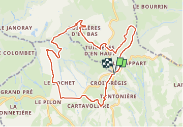
Trail On foot of 10.4 km to be discovered at Auvergne-Rhône-Alpes, Rhône, Les Haies. This trail is proposed by Clubléorando.
Description
Balade en boucle au départ du Parking de Croix Régis. Emprunter Routes, chemins et sentiers pour effectuer une boucle en passant par les hameaux de Bochet, les Tuillières d'en bas et d'en haut. Passer en dessous du Pet du Loup avant l'arrivée au parking du départ
Positioning
Country:
France
Region :
Auvergne-Rhône-Alpes
Department/Province :
Rhône
Municipality :
Les Haies
Location:
Unknown
Start:(Dec)
Start:(UTM)
636190 ; 5042427 (31T) N.
Comments
Trails nearby
![Trail Walking Loire-sur-Rhône - 42 le grisard (vienne) - Photo](https://media.geolcdn.com/t/375/260/c8c552c2-c833-47f9-98c4-fadea207952f.jpg&format=jpg&maxdim=2)
![Walking Walking](https://static1.geolcdn.com/sitytour/trail-icons/101.png)
42 le grisard (vienne)
Walking
Very easy
Loire-sur-Rhône,
Auvergne-Rhône-Alpes,
Rhône,
France
![](/images/other/stat-length.png)
5.6 km | 8.2 km-effort
2h 8min
![](https://static1.geolcdn.com/siteimages/upload/files/16400158638029165_repeat_loop_refresh_sync_direction_icon.png)
Yes
![Trail Walking Saint-Romain-en-Gal - le grisard - Photo](https://media.geolcdn.com/t/375/260/ext.jpg?maxdim=2&url=https%3A%2F%2Fstatic1.geolcdn.com%2Fsiteimages%2Fupload%2Ffiles%2F1553511878bg_sport_marche.png)
![Walking Walking](https://static1.geolcdn.com/sitytour/trail-icons/101.png)
le grisard
Walking
Medium
(1)
Saint-Romain-en-Gal,
Auvergne-Rhône-Alpes,
Rhône,
France
![](/images/other/stat-length.png)
5.3 km | 7.9 km-effort
1h 48min
![](https://static1.geolcdn.com/siteimages/upload/files/16400158638029165_repeat_loop_refresh_sync_direction_icon.png)
Yes
![Trail Walking Échalas - 69-echalas-17km-450m - Photo](https://media.geolcdn.com/t/375/260/668703a5-09d9-4217-ad43-166e3f818dc1.jpg&format=jpg&maxdim=2)
![Walking Walking](https://static1.geolcdn.com/sitytour/trail-icons/101.png)
69-echalas-17km-450m
Walking
Difficult
Échalas,
Auvergne-Rhône-Alpes,
Rhône,
France
![](/images/other/stat-length.png)
17.4 km | 23 km-effort
5h 17min
![](https://static1.geolcdn.com/siteimages/upload/files/16400158638029165_repeat_loop_refresh_sync_direction_icon.png)
Yes
![Trail Walking Loire-sur-Rhône - 69-loire-sur-rhone2-pet-de-loup-18km-560m - Photo](https://media.geolcdn.com/t/375/260/ee6f14b8-8ed9-4a30-84a4-6a7d5babc72f.jpg&format=jpg&maxdim=2)
![Walking Walking](https://static1.geolcdn.com/sitytour/trail-icons/101.png)
69-loire-sur-rhone2-pet-de-loup-18km-560m
Walking
Medium
(1)
Loire-sur-Rhône,
Auvergne-Rhône-Alpes,
Rhône,
France
![](/images/other/stat-length.png)
17.7 km | 25 km-effort
3h 3min
![](https://static1.geolcdn.com/siteimages/upload/files/16400158638029165_repeat_loop_refresh_sync_direction_icon.png)
Yes
![Trail Walking Longes - 1 septembre 2022 longes - Photo](https://media.geolcdn.com/t/375/260/b8e593b2-5bab-42a8-9612-49feaf9d31d5.jpg&format=jpg&maxdim=2)
![Walking Walking](https://static1.geolcdn.com/sitytour/trail-icons/101.png)
1 septembre 2022 longes
Walking
Difficult
Longes,
Auvergne-Rhône-Alpes,
Rhône,
France
![](/images/other/stat-length.png)
23 km | 35 km-effort
6h 40min
![](https://static1.geolcdn.com/siteimages/upload/files/16400158638029165_repeat_loop_refresh_sync_direction_icon.png)
Yes
![Trail Walking Longes - 69-longes-Mont-Monnet-Ste-Croix-Jarez-20km-800m - Photo](https://media.geolcdn.com/t/375/260/ac0cbb02-60a0-4176-82bd-78c0bd941465.jpg&format=jpg&maxdim=2)
![Walking Walking](https://static1.geolcdn.com/sitytour/trail-icons/101.png)
69-longes-Mont-Monnet-Ste-Croix-Jarez-20km-800m
Walking
Difficult
Longes,
Auvergne-Rhône-Alpes,
Rhône,
France
![](/images/other/stat-length.png)
20 km | 31 km-effort
6h 5min
![](https://static1.geolcdn.com/siteimages/upload/files/16400158638029165_repeat_loop_refresh_sync_direction_icon.png)
Yes
![Trail Walking Loire-sur-Rhône - 69-Loire-sur-Rhone-17km-480m-avr22 - Photo](https://media.geolcdn.com/t/375/260/13a86102-41dd-4011-b432-58d1cdb1bc2f.jpg&format=jpg&maxdim=2)
![Walking Walking](https://static1.geolcdn.com/sitytour/trail-icons/101.png)
69-Loire-sur-Rhone-17km-480m-avr22
Walking
Medium
Loire-sur-Rhône,
Auvergne-Rhône-Alpes,
Rhône,
France
![](/images/other/stat-length.png)
16.7 km | 23 km-effort
5h 9min
![](https://static1.geolcdn.com/siteimages/upload/files/16400158638029165_repeat_loop_refresh_sync_direction_icon.png)
Yes
![Trail On foot La Chapelle-Villars - Pilat N°30: des «Côteaux à les Haies» - Photo](https://media.geolcdn.com/t/375/260/dcae721c-56d2-4080-8395-c9b2db29b909.jpeg&format=jpg&maxdim=2)
![On foot On foot](https://static1.geolcdn.com/sitytour/trail-icons/100.png)
Pilat N°30: des «Côteaux à les Haies»
On foot
Difficult
La Chapelle-Villars,
Auvergne-Rhône-Alpes,
Loire,
France
![](/images/other/stat-length.png)
29 km | 37 km-effort
8h 27min
![](https://static1.geolcdn.com/siteimages/upload/files/16400158638029165_repeat_loop_refresh_sync_direction_icon.png)
Yes
![Trail Walking Ampuis - AMPUIS JC - Photo](https://media.geolcdn.com/t/375/260/ext.jpg?maxdim=2&url=https%3A%2F%2Fstatic1.geolcdn.com%2Fsiteimages%2Fupload%2Ffiles%2F1553511878bg_sport_marche.png)
![Walking Walking](https://static1.geolcdn.com/sitytour/trail-icons/101.png)
AMPUIS JC
Walking
Very easy
(1)
Ampuis,
Auvergne-Rhône-Alpes,
Rhône,
France
![](/images/other/stat-length.png)
9.7 km | 12.1 km-effort
3h 10min
![](https://static1.geolcdn.com/siteimages/upload/files/16400158638029165_repeat_loop_refresh_sync_direction_icon.png)
Yes